
Ultimate Ha Giang Loop Map and Route Guide 2026: 4-Day Motorcycle Itinerary

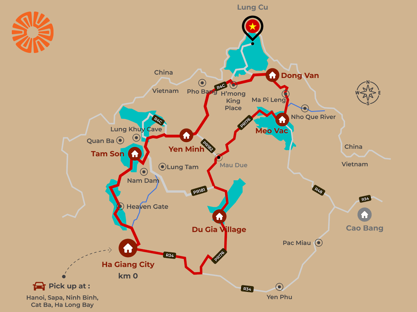
Navigating Northern Vietnam’s most legendary mountain circuit requires clear route planning. The Ha Giang Loop spans over 350 to 420 kilometers of sharp switchbacks, steep mountain passes, and dramatic karst limestone plateaus. Having a detailed, reliable Ha Giang Loop map is essential for a safe and seamless self-guided adventure.
This comprehensive guide breaks down the full 4-day route, complete with distances, elevation tips, key stopovers, and an interactive Google My Map you can save directly to your smartphone.
🗺️ Interactive Ha Giang Loop Google Map
Below is the customized route map outlining the classic 4-day loop, including scenic viewpoints, fuel stations, key mountain passes, and village stopovers.
📌 Open the Interactive Ha Giang Loop Map on Google Maps
(Pro Tip: Open this link in your Google Maps app before setting off and download the region for offline navigation, as cellular service can drop in deep valleys).
📊 Quick Route Overview
| Parameter | Details |
|---|---|
| Total Distance | ~380 km – 420 km (depending on side trips) |
| Pace | 4 Days / 3 Nights on the road (or 4D5N including Hanoi travel) |
| Start & End Point | Ha Giang City |
| Direction | Counter-Clockwise (Recommended for gradual elevation gains) |
| Terrain | Paved asphalt, steep hairpin turns, mountain passes, occasional gravel/under-construction zones |
🏍️ Detailed 4-Day Day-by-Day Route Breakdown
Day 1: Ha Giang City to Dong Van Town
- Distance: ~145 km
- Estimated Riding Time: 5 – 6 hours
- Primary Roads: QL4C (National Highway 4C)
- Key Map Waypoints: Ha Giang City ➔ Bac Sum Pass ➔ Quan Ba Heaven Gate ➔ Twin Mountains ➔ Tham Ma Slope ➔ Hmong King’s Palace ➔ Dong Van Ancient Town
Route & Driving Highlights
- Ha Giang City to Quan Ba (~50 km): Start by riding north on QL4C. The flat roads quickly give way to the winding curves of Bac Sum Pass. At the top sits Quan Ba Heaven Gate (Gate of Heaven), offering panoramic views over the valley and the iconic Co Tien Twin Mountains.
- Quan Ba to Yen Minh (~45 km): The road winds down into pine forests and river valleys before climbing again toward Yen Minh Town. This is a primary spot to refuel and eat lunch.
- Yen Minh to Dong Van (~50 km): Conquer the famous S-curves of Tham Ma Slope, a favorite photo location. Continue through the Dong Van Karst Plateau Geopark, taking a short detour to visit the historic Hmong King’s Palace (Dinh Vua H’Mong) in Sa Phin before arriving in Dong Van Town.
Day 2: Dong Van to Du Gia Village via Ma Pi Leng Pass
- Distance: ~100 km
- Estimated Riding Time: 4 – 5 hours
- Primary Roads: QL4C ➔ DT182 / Local mountain tracks
- Key Map Waypoints: Dong Van ➔ Ma Pi Leng Pass ➔ Sky Walk Lookout ➔ Nho Que River (Tu San Canyon) ➔ Meo Vac ➔ Mau Due ➔ Du Gia Village
Route & Driving Highlights
- Dong Van to Meo Vac via Ma Pi Leng Pass (~25 km): Ride along one of Southeast Asia’s most spectacular roads. Ma Pi Leng Pass hugs vertical limestone cliffs overlooking the turquoise Nho Que River. Take the steep switchbacks down to the river bank for a boat trip through Tu San Canyon, the deepest canyon in the region.
- Meo Vac to Mau Due (~35 km): After Meo Vac town, leave the main highway and ride through rugged mountain passes with dramatic rock formations and minimal traffic.
- Mau Due to Du Gia (~40 km): The landscape shifts from bare limestone karst to lush terraced valleys and bamboo forests as you descend into the serene Tay ethnic settlement of Du Gia Village.
Day 3: Du Gia to Nam Dam Cultural Village
- Distance: ~90 km
- Estimated Riding Time: 3.5 – 4 hours
- Primary Roads: DT176 ➔ Thai An Road ➔ QL4C
- Key Map Waypoints: Du Gia Village ➔ Du Gia Waterfall ➔ Thai An Road ➔ Lung Tam Weaving Village ➔ Nam Dam Village (Quan Ba)
Route & Driving Highlights
- Morning at Du Gia Waterfall: Cool off with an early morning visit or swim at the clear mountain waterfall just outside the main village center.
- Du Gia to Quan Ba via Thai An (~65 km): Navigate the rustic Thai An Road, a scenic backroad route with sweeping valley vistas and quiet rustic hamlets.
- Lung Tam & Nam Dam (~25 km): Stop in Lung Tam Village to observe traditional Hmong hemp weaving crafts. Finish the day’s ride in Nam Dam Village, known for its traditional rammed-earth houses built by the Dao Cham ethnic community.
Day 4: Nam Dam Village to Ha Giang City
- Distance: ~80 km
- Estimated Riding Time: 3 hours
- Primary Roads: QL4C
- Key Map Waypoints: Nam Dam ➔ Lung Khuy Cave ➔ Bac Sum Pass ➔ Ha Giang City
Route & Driving Highlights
- Lung Khuy Cave Exploration: Take a short hike up to Lung Khuy Cave, one of the most remarkable limestone cavern systems on the Dong Van Geopark plateau, filled with ancient stalactites.
- Final Descent to Ha Giang City: Rejoin QL4C for the final leg back down Bac Sum Pass, completing the full circular loop back in Ha Giang City by mid-afternoon.
⛽ Logistics & Practical Navigation Tips
1. Gas Station (Petrol) Locations on the Map
Do not let your tank drop below 25%. Major petrol stations (Petrolimex) are marked on the map at:
- Ha Giang City (Multiple options)
- Tam Son Town (Quan Ba District)
- Yen Minh Town
- Dong Van Town
- Meo Vac Town
- Du Gia Village (Local small pump stations)
2. Road Conditions & Driving Precautions
- Sharp Blind Corners: Always stay firmly on the right side of the road on mountain curves. Honk your horn before entering sharp turns to alert oncoming trucks or construction vehicles.
- Gravel & Landslides: Rainy weather can cause loose gravel or minor rockfalls on mountain passes. Check local road reports during the rainy season (July – September).
- Speed Limits: Maintain a cautious speed of 25–40 km/h on mountain passes.
3. Essential Equipment Checklist
- Offline Maps: Download both Google Maps and Maps.me regions for offline navigation.
- Vehicle Check: Check brakes, tire pressure, lights, and horn every morning before riding.
- Riding Gear: Full-face or 3/4 helmet, elbow/knee pads, sturdy shoes, and high-visibility rain poncho.
❓ Frequently Asked Questions About the Ha Giang Loop Map
Riding counter-clockwise (Ha Giang ➔ Quan Ba ➔ Dong Van ➔ Meo Vac ➔ Du Gia ➔ Ha Giang) is generally preferred. This direction allows for a steady increase in road difficulty and places the grand vistas of Ma Pi Leng Pass on the second day.
Yes, a 3-day route is possible by skipping Du Gia and riding directly from Meo Vac back to Ha Giang via Yen Minh. However, a 4-day route is strongly recommended to avoid long, exhausting riding hours and to enjoy key stops like Nho Que River and Du Gia Waterfall.
Mountain roads in Ha Giang feature steep inclines and sharp switchbacks. If you do not have significant manual/semi-automatic motorcycle experience, consider riding pillion with an experienced local driver rather than riding self-drive.